Fotosearch Royalty Free Stock Photography
Digital images licensed by Publitek, Inc.
Fotosearch and Photosearch are trademarks of Fotosearch, LLC
All rights reserved © 2026-01-25
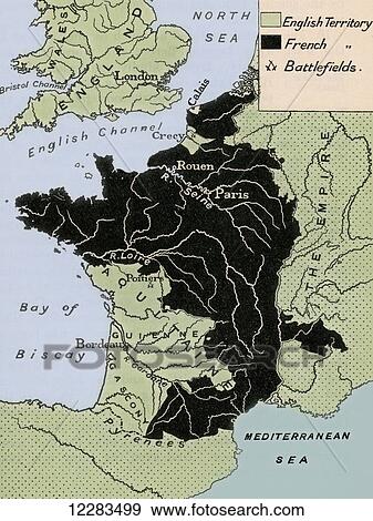
Map showing the English dominions in France after the Treaty of Calais in 1360. From A First Book of British History published 1925. Stock Photo

Map showing the English dominions in France after the Treaty of Calais in 1360. From A First Book of British History published 1925.
12283499 | Design Pics | Royalty Free
Add to Lightbox
Share Image
Keywords
1360, 14th, ages, bretigny, calais, century, countries, country, design pics, dominions, english, fourteenth, france, geography, historical, history, map, mediaeval, medieval, middle, treaty, stock image, images, royalty free photo, stock photos, stock photograph, stock photographs, picture, pictures, graphic, graphics, fine art prints, print, poster, posters, mural, wall murals, 12283499
1360, 14th, ages, bretigny, calais, century, countries, country, design pics, dominions, english, fourteenth, france, geography, historical, history, map, mediaeval, medieval, middle, treaty, stock image, images, royalty free photo, stock photos, stock photograph, stock photographs, picture, pictures, graphic, graphics, fine art prints, print, poster, posters, mural, wall murals, 12283499
Show Keywords
- Ultra High Resolution (52.3 MB)12.4" x 16.4" @ 300dpi JPG999999
View larger image sizes
View Design Pics license agreement


